
by Matteo Picchiani*
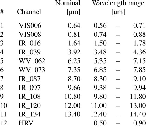
GMATICS have developed a prototypal version of the meteorological Nowcasting module based on EUMETSAT Meteosat Second Generation (MSG) data. The characteristics of the 12 spectral channels of the SEVIRI (Spinning Enhanced Visible and InfraRed Imager) sensor, on board of the MSG satellite are reported in the following table 1.

The DYDAS meteorological Nowcasting model has been implemented for assimilating the input variables as derived by the MSG spectral channels and subsequently to compute the prediction of the cloud’s movement for 90 minutes ahead each new MSG observation, with a step of 15 minutes. Moreover, the DYDAS meteorological Nowcasting model is capable of identifying the possible meteorological clouds generating thunderstorms. Such events are produced by the so-called convective cells.
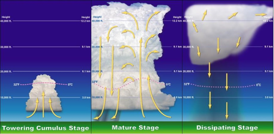
The potential stages of a convective cell are depicted in the following diagram. The cumulus stage, also known as the developing stage, is the first phase of a thunderstorm. Masses of moisture are being lifted into the atmosphere at this moment. Through the mechanism of convection, the air has a propensity to ascend in an updraft (hence the term convective precipitation). As a result, a low-pressure area develops beneath the developing thunderstorm. The warmed air rises during the mature stage of a thunderstorm until it hits a region of warmer air and is unable to rise any higher. This “cap” is frequently the tropopause. Instead, the air is compelled to expand out, giving the storm its recognizable anvil shape. The cumulonimbus incus that results from this process. The water droplets coalesce into larger and heavier droplets and freeze to become ice particles. As these falls they melt to become rain.
When an updraft is powerful enough, the droplets are kept in the air long enough to become so big that they don’t entirely melt and instead fall as hail. Downdrafts are also produced by the rain as well as updrafts, which are still present. When an updraft and a downdraft are present at the same time, the storm has reached its mature stage and is creating cumulonimbus clouds. However, if there is enough change in wind speed and/or direction, the downdraft will be separated from the updraft and the storm may develop into a supercell, and the mature stage can sustain itself for several hours. Normally, if there is little wind shear, the storm will quickly enter the dissipating stage and “rain itself out.” The downdraft still rules the thunderstorm as it dissipates. If atmospheric conditions do not support super cellular development, this stage occurs rather quickly, approximately 20–30 minutes into the life of the thunderstorm. The downdraft will push down out of the thunderstorm, hit the ground and spread out. This phenomenon is known as a downburst. The cool air carried to the ground by the downdraft cuts off the inflow of the thunderstorm, the updraft disappears and the thunderstorm will dissipate. DYDAS meteorological Nowcasting is suitable to monitoring the whole life cycle of the convective cell by means of its detector and tracker functionality.

The DYDAS meteorological Nowcasting algorithm uses several channels of the MSG for the early detection and the nowcasting of stormy objects.
The detector makes use of the 6.2 μm (channel 5) and 7.3 μm (channel 6) water vapor wavelengths together with the 10.8 μm (channel 9) wavelength in order to detect the base and the nuclei of the cells, without any threshold, differently from other algorithms in the literature. At this step, some features, like the geometry and the level of hazard, are computed.
The final step is the nowcasting of the detected cells by performing the forecast of the MSG spectral channels.
The forecast is performed by an Artificial Intelligence (AI) model for short-range forecast (15 – 90 minutes). Overall, the prediction interval ranges from 15 minutes to 90 minutes ahead with a step of 15 minutes.
The aim of the AI model is to propagate all the spectral information of the MSG channels in order to subsequently apply again the detection procedure for recognizing the clouds objects. In such way the radiometric information is forecasted in order to produce the prediction of the MSG channels from 30 minutes to 90 minutes ahead each new MSG observation.
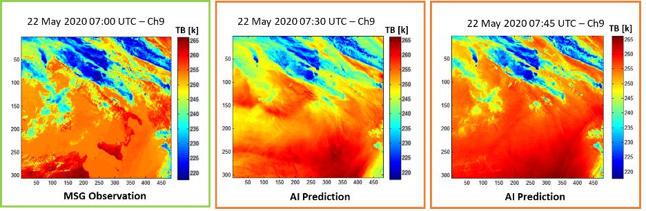
An example of the AI Nowcasting for the MSG channel 9 is shown in figure 1.
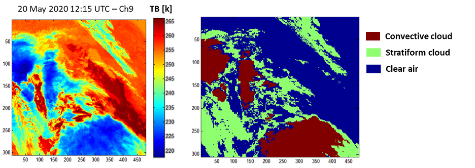
Finally an example of the cloud detection prototype is reported in figure 2.
*Matteo Picchiani, Engineer, Chief Technical Officer at GMATICS
Modello di Nowcasting meteorologico DYDAS
GMATICS ha sviluppato una versione prototipo del modulo meteorologico Nowcasting basato sui dati EUMETSAT Meteosat Second Generation (MSG). Le caratteristiche dei 12 canali spettrali del sensore SEVIRI (Spinning Enhanced Visible and InfraRed Imager), a bordo del satellite MSG, sono riportate nella seguente tabella 1.
Il modello DYDAS meteorologico Nowcasting è stato implementato per assimilare le variabili di input come derivate dai canali spettrali MSG e successivamente per calcolare la previsione del movimento della nuvola per 90 minuti prima di ogni nuova osservazione MSG, con un passo di 15 minuti. Inoltre, il modello DYDAS meteorological Nowcasting è in grado di identificare le possibili nubi meteorologiche che generano temporali. Tali eventi sono prodotti dalle cosiddette celle convettive.
I potenziali stadi di una cella convettiva sono illustrati nel diagramma seguente. Lo stadio del cumulo, noto anche come stadio di sviluppo, è la prima fase di un temporale. Masse di umidità vengono sollevate nell’atmosfera in questo momento. Attraverso il meccanismo della convezione, l’aria ha una propensione a salire in una corrente ascensionale (da cui il termine precipitazione convettiva). Di conseguenza, un’area di bassa pressione si sviluppa sotto il temporale in via di sviluppo. L’aria riscaldata sale durante la fase matura di un temporale fino a quando non colpisce una regione di aria più calda e non è in grado di salire più in alto. Questo “cappello” è spesso la tropopausa. Invece, l’aria è costretta ad espandersi, dando alla tempesta la sua riconoscibile forma a incudine. Il cumulonembo incus che risulta da questo processo. Le goccioline d’acqua si fondono in goccioline più grandi e più pesanti e si congelano per diventare particelle di ghiaccio. Quando queste cascate si sciolgono per diventare pioggia.
Quando una corrente ascensionale è abbastanza potente, le goccioline vengono mantenute nell’aria abbastanza a lungo da diventare così grandi da non sciogliersi completamente e cadere invece come grandine. Le correnti discendenti sono prodotte anche dalla pioggia e dalle correnti ascensionali, che sono ancora presenti. Quando una corrente ascensionale e una discendente sono presenti contemporaneamente, la tempesta ha raggiunto la sua fase matura e sta creando cumulonembi. Tuttavia, se c’è un cambiamento sufficiente nella velocità e/o nella direzione del vento, la corrente discendente sarà separata dalla corrente ascensionale e la tempesta potrebbe trasformarsi in una supercella e lo stadio maturo può sostenersi per diverse ore. Normalmente, se c’è poco wind shear, la tempesta entrerà rapidamente nella fase di dissipazione e “pioverà da sola”. La corrente discendente governa ancora il temporale mentre si dissipa. Se le condizioni atmosferiche non supportano lo sviluppo supercellulare, questa fase si verifica piuttosto rapidamente, a circa 20-30 minuti dall’inizio della vita del temporale. Il downdraft si spingerà fuori dal temporale, colpirà il suolo e si allargherà. Questo fenomeno è noto come downburst. L’aria fresca portata a terra dalla corrente discendente interrompe l’afflusso del temporale, la corrente ascensionale scompare e il temporale si dissiperà. Il Nowcasting meteorologico DYDAS è adatto a monitorare l’intero ciclo di vita della cella convettiva tramite la sua funzionalità di detector e tracker.
L’algoritmo di Nowcasting meteorologico DYDAS utilizza diversi canali dell’MSG per il rilevamento precoce e il nowcasting di oggetti tempestosi.
Il rivelatore utilizza le lunghezze d’onda del vapore acqueo di 6,2 μm (canale 5) e 7,3 μm (canale 6) insieme alla lunghezza d’onda di 10,8 μm (canale 9) per rilevare la base e i nuclei delle cellule, senza alcuna soglia, in modo diverso da altri algoritmi in letteratura. In questa fase vengono calcolate alcune caratteristiche, come la geometria e il livello di pericolo.
Il passaggio finale è il nowcasting delle cellule rilevate eseguendo la previsione dei canali spettrali MSG.
La previsione è eseguita da un modello di Intelligenza Artificiale (AI) per previsioni a corto raggio (15 – 90 minuti). Complessivamente, l’intervallo di previsione varia da 15 minuti a 90 minuti in anticipo con un passo di 15 minuti.
Lo scopo del modello AI è quello di propagare tutte le informazioni spettrali dei canali MSG per poi applicare nuovamente la procedura di rilevamento per il riconoscimento degli oggetti delle nuvole. In tal modo si prevede l’informazione radiometrica in modo da produrre la previsione dei canali MSG da 30 minuti a 90 minuti prima di ogni nuova osservazione MSG.
Un esempio di AI Nowcasting per il canale MSG 9 è mostrato nella figura 1.

Infine, un esempio del prototipo di rilevamento del cloud è riportato in figura 2.

*Matteo Picchiani, Engineer, Chief Technical Officer at GMATICS