
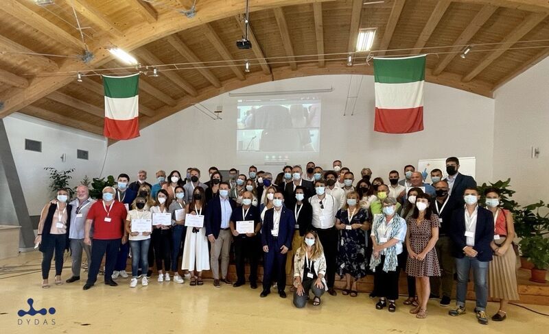
DYDAS è stato presentato alla terza edizione del Training Camp Ventotene organizzata da ANCI Lazio, lo scorso 13, 14 e 15 settembre.
Circa 60 amministratori della regione Lazio hanno avuto occasione di incontrarsi e partecipare ad alcuni momenti formativi sulla splendida isola del Tirreno che diede i natali alla prima idea di Unione Europea portata da Altieri Spinelli. Come espresso da Riccardo Varone, Presidente di ANCI Lazio, “Anci Lazio grazie anche al favorevole contributo della Regione Lazio, supporta con il proprio CTS tutti i comuni che vogliono cogliere le possibilità date dai bandi europei, uno strumento unico che il nostro Paese deve imparare ad utilizzare con maggiore capacità operativa”.
ANCI Lazio sta portando avanti ormai da diversi anni un percorso si supporto e formazione degli amministratori. Il documento guida di questa edizione è quello elaborato proprio dal CTS, quel “Costruire Comune”, che ha tra i suoi obiettivi quello di elaborare strategie concrete dei comuni rispetto alla programmazione 2021-2027, con lo scopo azzerare le disuguaglianze territoriali nella regione Lazio, utilizzando gli strumenti del Next Generation EU e del Recovery Fund e investire sulla comunità locali.
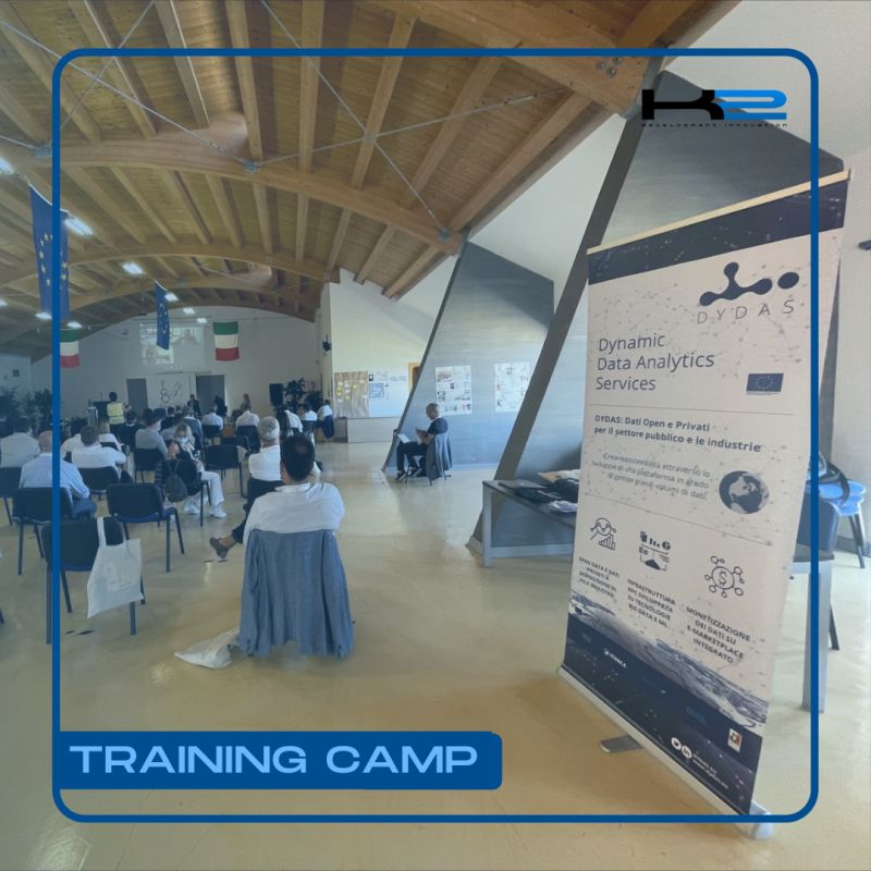
La piattaforma DYDAS – Dynamic Data Analytics Services è stata presentata da Iulian Coltea, IT Manager di Key To Business (capofila del progetto europeo DYDAS) al fine di dimostrare l’opportunità e la capacità di gestire e permettere di analizzare enormi volumi di dati dinamici, nel contesto degli open data e promuovendo la condivisione e il riuso dei dati, specialmente quelli certificati come dati open dalle pubbliche amministrazioni di livello nazionale, regionale e locale.
Una piattaforma, quella di DYDAS che fornirà anche un servizio di e-marketplace per l’utilizzo di servizi di più alto livello, sfruttando le tecnologie utilizzate dall’High Performance Computing, ovvero un sistema di elaborazione in grado di fornire delle prestazioni molto elevate nell’ordine dei PetaFLOPS (numero di operazioni eseguite in un secondo dalla CPU). Considerando che un sistema informatico da 1 petaFLOPS (PFLOPS) è in grado di eseguire un quadrilione di operazioni in virgola mobile al secondo. Il tasso 1 PFLOPS equivale a 1.000 TFLOPS. Per abbinare ciò che un sistema informatico da 1 PFLOPS può fare in un solo secondo, si dovrebbe infatti eseguire un calcolo ogni secondo per 31.688.765 anni. Una delle caratteristiche peculiari della piattaforma DYDAS è di permettere l’utilizzo di dati geospaziali, anche molto eterogenei, e ciò viene attuato sfruttando le capacità della piattaforma di gestire le varie tipologie di dati geospaziali che principalmente si riferiscono a dati di natura vettoriale (ovvero dei poligoni e astrazioni della realtà attraverso forme poligonali e metadati) oppure attraverso dati raster (rappresentazioni composti da matrici di pixel) e attraverso la Geospatial Data Model e la serie di regole per l’interoperabilità, il sistema DYDAS ha implementato un’architettura denominata Geospatial Data Architecture, che permette agli utenti di utilizzare e gestire il formato di dati in maniera “seamless”, ovvero senza preoccuparvi di dover fare operazioni specifiche per il cambiamento di formati, proiezioni geografiche e quant’altro. Ciò permette l’utilizzo di una grandissima quantità di dati geospaziali differenti fra loro come per esempio dati catastali, foto aeree o dati satellitari, il database open di OpenStreetMap così come altre tipologie di dati cartografici o tipologie di mappe rappresentanti quantità geofisiche come per es. la temperatura superficiale, o il rischio legato alla meteorologia, per quanto riguarda gli eventi estremi. Ciò abilita la produzione di servizi, da quelli più semplici, di interesse del comune cittadino, come quelli relativi alla meteorologia, fino a servizi più complessi e implementati da qualsiasi soggetto. Quindi da soggetti privati così come da soggetti pubblici, imprese, ma anche istituti accademici e di ricerca.
DYDAS presented at the 2021 Training Camp in Ventotene
DYDAS was presented at the third edition of the Ventotene Training Camp organized by ANCI Lazio, last 13, 14 and 15 September.
About 60 administrators of the Lazio region had the opportunity to meet and participate in some training sessions on the splendid island of the Tyrrhenian Sea which gave birth to the first idea of a European Union brought by Altieri Spinelli. As expressed by Riccardo Varone, President of ANCI Lazio, “Anci Lazio, thanks also to the favorable contribution of the Lazio Region, supports with its CTS all the municipalities that want to take advantage of the opportunities given by the European calls, a unique tool that our country must learn to use with greater operational capacity “.
ANCI Lazio has been pursuing a path of support and training for administrators for several years now. The guiding document of this edition is the one developed by the CTS, that “Building Municipality”, which has among its objectives that of elaborating concrete strategies of the municipalities with respect to the 2021-2027 programming, with the aim of eliminating territorial inequalities in the Lazio region, using the tools of the Next Generation EU and the Recovery Fund and investing in the local community.
The DYDAS – Dynamic Data Analytics Services platform was presented by Iulian Coltea, IT Manager of Key To Business (lead partner of the DYDAS European project) in order to demonstrate the opportunity and the ability to manage and allow to analyze huge volumes of dynamic data, in the context of open data and promoting the sharing and reuse of data, especially those certified as open data by public administrations at national, regional and local level.
A platform, that of DYDAS, which will also provide an e-marketplace service for the use of higher-level services, exploiting the technologies used by High Performance Computing, that is a processing system capable of providing very high performance in order of PetaFLOPS (number of operations performed in one second by the CPU). Whereas a 1 petaFLOPS computer system (PFLOPS) is capable of executing a quadrillion floating point operations per second. The 1 PFLOPS rate is equivalent to 1,000 TFLOPS. To match what a 1 PFLOPS computer system can do in just one second, one would have to do a calculation every second for 31,688,765 years. One of the peculiar characteristics of the DYDAS platform is to allow the use of geospatial data, even very heterogeneous, and this is implemented by exploiting the platform’s capabilities to manage the various types of geospatial data that mainly refer to vector data (i.e. polygons and abstractions of reality through polygonal shapes and metadata) or through raster data (representations made up of pixel arrays) and through the Geospatial Data Model and the set of rules for interoperability, the DYDAS system has implemented an architecture called Geospatial Data Architecture, which allows users to use and manage the data format in a “seamless” way, ie without worrying about having to do specific operations for changing formats, geographical projections and so on. This allows the use of a huge amount of different geospatial data such as cadastral data, aerial photos or satellite data, the OpenStreetMap open database as well as other types of cartographic data or types of maps representing geophysical quantities such as for example. the surface temperature, or the risk related to meteorology, with regard to extreme events. This enables the production of services, from the simplest ones, of interest to the common citizen, such as those relating to meteorology, to more complex services implemented by any subject. Therefore, from private entities as well as from public entities, businesses, but also academic and research institutes.