
a cura di Matteo Picchiani*
I satelliti per l’osservazione della Terra differiscono tra loro per alcuni parametri stabiliti nella fase di programmazione della missione, che vengono definiti in base alle funzioni che i satelliti dovranno svolgere, come ad esempio: il tipo di orbita, il carico utile, la risoluzione spaziale, le caratteristiche spettrali e l’ampiezza di scansione dei sensori relativa ai loro sistemi di imaging. Di seguito sono riportati alcuni esempi in relazione alla tipologia di servizio:
- Per monitorare le condizioni meteorologiche su vaste aree e con alta frequenza, è utile che il satellite si trovi in orbita geostazionaria, ovvero in un tipo di orbita in cui il sensore può osservare in modo quasi continuo un intero emisfero. Poiché l’orbita è molto alta (circa 36.000 chilometri dalla Terra) è difficile ottenere un’alta risoluzione spaziale, ma questa non risulta necessaria per applicazioni come l’osservazione dei sistemi nuvolosi sui continenti.
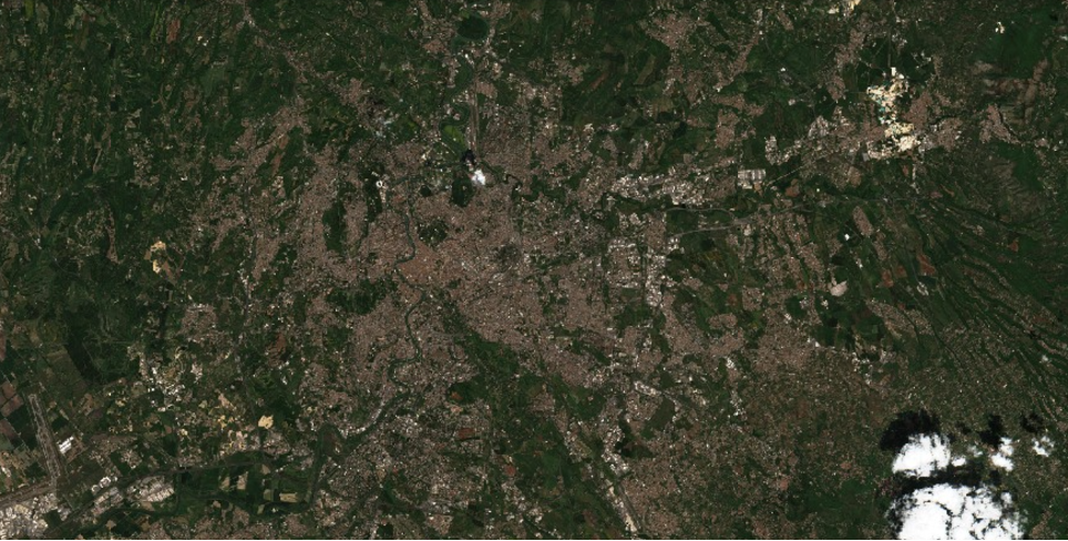
- Per monitorare le infrastrutture (quindi per ottenere immagini ad alta risoluzione di un’area molto specifica) è invece necessario un sensore ad alta risoluzione spaziale. Quest’ultimo ha generalmente un’ampiezza di scansione ridotta ed è installato su un satellite LEO, cioè in bassa orbita terrestre (generalmente tra 600 e 800 chilometri dalla Terra). In un’orbita di questo tipo non è possibile monitorare in modo continuo la stessa area a causa del movimento relativo del satellite rispetto alla Terra. Le immagini di una determinata area possono essere acquisite solo quando il satellite passa sopra di essa. Questa caratteristica è oggi massimizzata grazie a costellazioni di mini-satelliti che, essendo formate da centinaia di satelliti con le stesse caratteristiche, permettono di implementare un monitoraggio ad alta risoluzione spaziale e con tempo di rivisita giornaliero.
Tra i dati geospaziali ai quali sarà possibile accedere tramite la piattaforma DYDAS, gli utenti troveranno anche dei prodotti satellitari e in particolar modo i dati delle missioni europee Copernicus.
Copernicus Sentinel-2
La missione Copernicus Sentinel-2 comprende una costellazione di due satelliti in orbita polare posti nella stessa orbita sincrona con il sole, sfasati a 180° l’uno rispetto all’altro. L’obiettivo è di monitorare la variabilità delle condizioni della superficie terrestre e la sua ampia larghezza della swath (290 km) e l’alto tempo di rivisitazione (10 giorni all’equatore con un satellite e 5 giorni con 2 satelliti in condizioni senza nuvole, che si traduce in 2-3 giorni alle medie latitudini) supporta il monitoraggio dei cambiamenti della superficie terrestre.
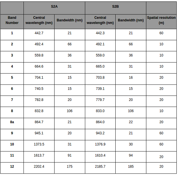
Sentinel-2 trasporta uno strumento ottico, denominato MultiSpectral Instrument (MSI), che campiona 13 bande spettrali: quattro bande a 10 m, sei bande a 20 m e tre bande a 60 m di risoluzione spaziale. La larghezza della swath orbitale è di 290 km (si veda tabella seguente).

L’orbita è Sun synchronous a 786 km di altitudine con un nodo discendente alle 10:30. Questa ora locale è stata scelta come compromesso tra la riduzione al minimo della copertura nuvolosa e la garanzia di un’adeguata illuminazione solare. Questo parametro è vicino all’ora locale di Landsat (missione della NASA arrivata alla 9 generazione di satelliti) consentendo la combinazione dei dati di Sentinel-2 con le immagini storiche della missione NASA per costruire serie temporali a lungo termine.
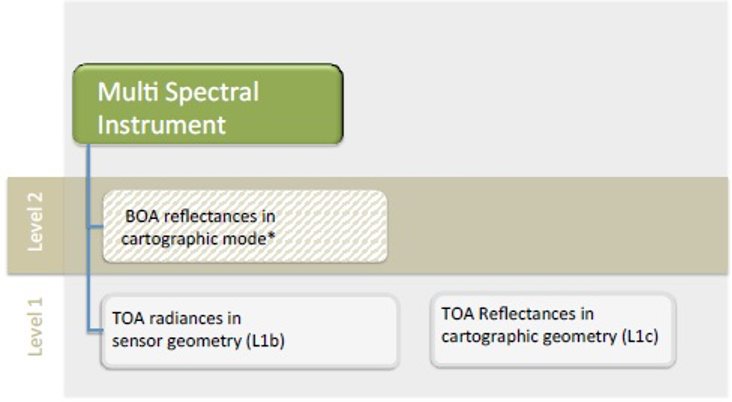
Le principali applicazioni relative all’impiego dei dati Sentinel-2 includono il monitoraggio dell’uso e consumo del suolo, l’agricoltura in connessione allo stato di salute della vegetazione agricola, monitoraggio e gestione del patrimonio forestale, monitoraggio delle acque interne e costiere, impiego nella gestione di crisi nell’ambito di protezione civile. Nella figura seguente sono riportate le informazioni principali relative ai prodotti Sentinel-2 e alla relazione tra Livello 1 e Livello 2 dei dati forniti da Copernicus.

Copernicus Sentinel-1
La missione Sentinel-1 comprende una costellazione di due satelliti in orbita polare, che operano giorno e notte acquisendo immagini radar ad apertura sintetica in banda C, consentendo di raccogliere immagini indipendentemente dalle condizioni meteorologiche.
La missione Sentinel-1 è basata su un sensore RADAR sviluppato nell’iniziativa congiunta tra programma Copernicus della Commissione europea (CE) e dell’Agenzia spaziale europea (ESA).
La missione Sentinel-1 trasporta come payload l’imaging RADAR e apertura sintetica (SAR) in banda C che opera in quattro modalità di imaging esclusive con diverse risoluzioni (fino a 10 m) e copertura (fino a 400 km di swath). Il sensore fornisce capacità di doppia polarizzazione (bande VV+VH o HH+HV), tempi di rivisita molto brevi (fino a 6 giorni alle medie latitudine europee) e consegna rapida del prodotto. Per ogni osservazione sono disponibili misurazioni precise della posizione e dell’assetto del veicolo spaziale, fondamentali per le analisi di tipo interferometrico.
La missione è composta da una costellazione di due satelliti, Sentinel-1A e Sentinel-1B, che condividono lo stesso piano orbitale.
Sentinel-1 è progettato per funzionare in una modalità operativa preprogrammata e priva di conflitti, per acquisire immagini di tutte le masse continentali, delle zone costiere e delle rotte marittime globali ad alta risoluzione e coprire l’oceano globale con tile a risoluzione più bassa. Ciò garantisce l’affidabilità del servizio richiesta dai servizi operativi e un archivio dati coerente a lungo termine creato per applicazioni basate su serie temporali lunghe.
I dati acquisiti dalla costellazione Sentinel-1 sono utilizzati in diversi settori applicativi come:
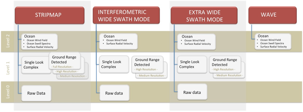
Monitoraggio della superficie terrestre in relazione all’uso del suolo, alla deforestazione e all’agricoltura; monitoraggio della superficie marina in relazione alla presenza di ghiaccio, agli sversamenti di olio combustibile e alla presenza di navi; monitoraggio degli effetti dei terremoti e della stabilità delle superfici; monitoraggio dei ghiacciai. Nella figura seguente sono rappresentate le principali informazioni relative ai prodotti Sentinel-1 e alle relazioni tra i vari livelli di dati.
*Matteo Picchiani, Chief Technical Officer in GMATICS
Usability of Copernicus data in the DYDAS digital platform
by Matteo Picchiani*
Earth observation satellites differ from each other in some parameters established in the programming phase of the mission, which are defined according to the functions that the satellites will have to perform, such as: the type of orbit, the payload, the spatial resolution, the spectral characteristics and the scanning amplitude of the sensors related to their imaging systems. Below are some examples in relation to the type of service:
- To monitor weather conditions over large areas and with high frequency, it is useful for the satellite to be in geostationary orbit, that is, in a type of orbit in which the sensor can observe an entire hemisphere almost continuously. Since the orbit is very high (about 36. 000 kilometers from Earth) it is difficult to obtain a high spatial resolution, but this is not necessary for applications such as the observation of cloud systems on the continents.
- To monitor the infrastructure (therefore to obtain high-resolution images of a very specific area) a sensor with high spatial resolution is required. The latter generally has a reduced scanning width and is installed on a LEO satellite, that is, in low Earth orbit (generally between 600 and 800 kilometers from Earth). In such an orbit it is not possible to continuously monitor the same area due to the relative movement of the satellite relative to the Earth. Images of a certain area can only be acquired when the satellite passes over it. This feature is now maximized thanks to constellations of mini-satellites that, being formed by hundreds of satellites with the same characteristics, allow to implement a monitoring with high spatial resolution and with daily revisit time.
Among the geospatial data that can be accessed through the DYDAS platform, users will also find satellite products and in particular the data of the European Copernicus missions.
Copernicus Sentinel-2
The Copernicus Sentinel-2 mission includes a constellation of two satellites in polar orbit placed in the same orbit synchronous with the sun, out of phase at 180° with respect to each other. The goal is to monitor the variability of the conditions of the Earth’s surface and its wide width of the swath (290 km) and the high revisit time (10 days at the equator with a satellite and 5 days with 2 satellites in cloudless conditions, which translates into 2-3 days in the middle latitudes) supportsthe monitoring of changes in the Earth’s surface.
Sentinel-2 carries an optical instrument, called the MultiSpectral Instrument (MSI), which samples 13 spectral bands: four bands at 10 m, six bands at 20 m and three bands at 60 m spatial resolution. The width of the orbital swath is 290 km (see table below).
MSI Tool Specifications
The orbit is Sun synchronous at 786 km altitude with a descending node at 10:30. This local time was chosen as a compromise between minimizing cloud cover and ensuring adequate solar lighting. This parameter is close to the local time of Landsat (NASA’s mission arrived at the 9th generation of satellites) allowing the combination of Sentinel-2 data with historical images of the NASA mission to build long-term time series.
The main applications related to the use of Sentinel-2 data include monitoring land use and consumption, agriculture in connection with the health status of agricultural vegetation, monitoring and management of forest heritage, monitoring of inland and coastal waters, use in crisis management in the field of civil protection. The following figure shows the main information about Sentinel-2 products and the relationship between Level 1 and Level 2 of the data provided by Copernicus.

Copernicus Sentinel-1
The Sentinel-1 mission includes a constellation of two satellites in polar orbit, operating day and night by acquiring C-band synthetic aperture radar images, allowing images to be collected regardless of weather conditions.
The Sentinel-1 mission is based on a RADAR sensor developed in the joint initiative between the Copernicus programme of the European Commission (EC) and the European Space Agency (ESA).
The Sentinel-1 mission carries C-band RADAR and synthetic aperture (SAR) imaging as a payload that operates in four unique imaging modes with different resolutions (up to 10 m) and coverage (up to 400 km of swath). The sensor provides dual polarization capabilities (VV+VH or HH+HV bands), very short revisit times (up to 6 days in mid-latitude Europe) and fast product delivery. Precise measurements of the position and attitude of the spacecraft are available for each observation, which are essential for interferometricor analysis.
The mission consists of a constellation of two satellites, Sentinel-1A and Sentinel-1B, which share the same orbital plane.
Sentinel-1 is designed to operate in a pre-programmed, conflict-free mode of operation, to capture images of all landmass, coastal zones and global sea routes in high resolution, and to cover the global ocean with lower resolution tiles. This ensures the service reliability required by operational services and a consistent long-term data store built for long-series applications.
The data acquired by the Sentinel-1 constellation are used in different application sectors such as:
Monitoring of the earth’s surface in relation to land use, deforestation and agriculture; monitoring of the sea surface in relation to the presence of ice, fuel oil spills and the presence of ships; monitoring the effects of earthquakes and surface stability; glacier monitoring. The following figure shows the main information about Sentinel-1 products and the relationships between the various data layers.


*Matteo Picchiani, Chief Technical Officer in GMATICS