
by Matteo Picchiani*
In the sphere of VISTA project, two novel ground based systems have been developed, named “VIRSO2” and “IIRc” respectively. VIRSO2 instrument has three optical cameras, two TIR and one VIS, able to acquire data simultaneously at high frequency (~7 Hz) during both day and night. In order to retrieve the SO2 amount emitted from the volcano, an 8.7 μm filter is installed in front of one of the TIR cameras. IIRc system consists of single 320×240 uncoooled bolometric IR core sampling at up to 9 Hz and a 1.3 MPD visible camera. Both of these two instruments allow the detection of volcanic clouds and the estimation of their height. In addition, VIRSO2 system, after calibration and corrections for vignetting and filter effects, is able to retrieve the SO2 columnar abundance. Finally, the high frequency of the measurements permits to quantify the updraft speeds and/or wind vectors that can be used to estimate SO2 fluxes. The latter have been validated by exploiting the retrievals carried out from the ground based FLAME network on Etna and Stromboli, a UV ground based camera measurements (only for Etna field campaign) and from TROPOMI satellite data.
The following figures shows an example of the VIRSO2 and IIRc capabilities.
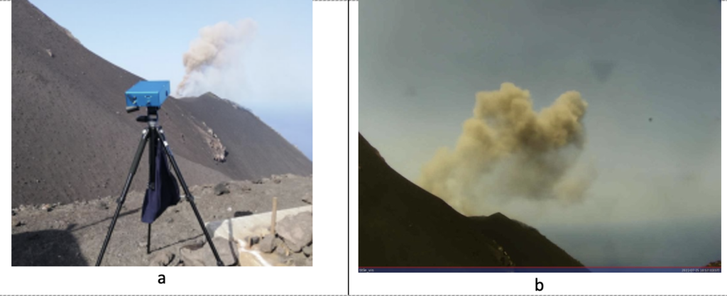
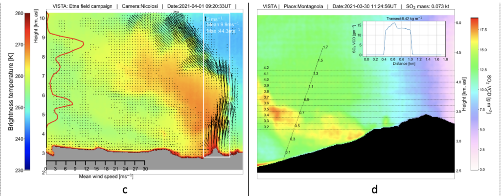
a) VIRSO2 instrument at Stromboli; b) A Strombolian explosion collected by the VIS camera of VIRSO2 (25 July 2021); c) Height and wind speed retrieval collected from Nicolosi (Etna 1 April 2021 eruption); d) SO2 vertical column density and transect selected for SO2 flux computation (Etna, La Montagnola 30 March 2021).
The ESA VISTA project is an excellent example of integration of Earth Observation data and other types of geospatial data, including measurements acquired by ground instruments.
These kinds of approaches can really benefit from the DYDAS platform components, such as the Geospatial Data Architecture (e.g., for a seamless integration of heterogeneous data) and the HPC functionalities that could be used for the evolution of services and their scaling up.
*Matteo Picchiani, Engineer, Chief Technical Officer at GMATICS
VISTA innovativi sistemi di monitoraggio a terra
Nell’ambito del progetto VISTA sono stati sviluppati due nuovi sistemi a terra, denominati rispettivamente “VIRSO2” e “IIRc”. Lo strumento VIRSO2 dispone di tre telecamere ottiche, due TIR e una VIS, in grado di acquisire dati contemporaneamente ad alta frequenza (~7 Hz) sia di giorno che di notte. Per recuperare la quantità di SO2 emessa dal vulcano, davanti a una delle telecamere TIR è installato un filtro da 8,7 μm. Il sistema IIRc è costituito da un singolo core campionamento IR bolometrico 320×240 non raffreddato fino a 9 Hz e una telecamera visibile da 1,3 MPD. Entrambi questi due strumenti consentono il rilevamento delle nubi vulcaniche e la stima della loro altezza. Inoltre, il sistema VIRSO2, dopo calibrazione e correzioni per effetti di vignettatura e filtro, è in grado di recuperare l’abbondanza colonnare di SO2. Infine, l’elevata frequenza delle misurazioni permette di quantificare le velocità di corrente ascensionale e/oi vettori del vento che possono essere utilizzati per stimare i flussi di SO2. Questi ultimi sono stati validati sfruttando i recuperi effettuati dalla rete terrestre FLAME sull’Etna e Stromboli, misurazioni di una camera UV terrestre (solo per la campagna sul campo dell’Etna) e dai dati satellitari TROPOMI.
Le figure seguenti mostrano un esempio delle capacità di VIRSO2 e IIRc.
a) strumento VIRSO2 a Stromboli; b) Un’esplosione stromboliana raccolta dalla telecamera VIS di VIRSO2 (25 luglio 2021); c) Recupero quota e velocità del vento raccolti da Nicolosi (eruzione Etna 1 aprile 2021); d) Densità della colonna verticale di SO2 e transetto selezionati per il calcolo del flusso di SO2 (Etna, La Montagnola 30 marzo 2021).
Il progetto ESA VISTA è un eccellente esempio di integrazione dei dati di osservazione della Terra e di altri tipi di dati geospaziali, comprese le misurazioni acquisite da strumenti a terra.
Questi tipi di approcci possono davvero trarre vantaggio dai componenti della piattaforma DYDAS, come la Geospatial Data Architecture (ad esempio, per una perfetta integrazione di dati eterogenei) e le funzionalità HPC che potrebbero essere utilizzate per l’evoluzione dei servizi e il loro scaling up.
*Matteo Picchiani, Engineer, Chief Technical Officer at GMATICS