
by Matteo Picchiani*
In parallel to the DYDAS activities, Matteo Picchiani (of GMATICS) leaded the development of the European Space Agency Volcanic monItoring using SenTinel sensors by an integrated Approach (VISTA) founded project (https://eo4society.esa.int/projects/vista/).
VISTA was carried out by GEO-K, the first spin-off of the Tor Vergata University, in collaboration with the Italian Istituto Nazionale di Geofisica e Vulcanologia and U.K.’s company AIRES TECH PLC.
This project was aimed at developing a novel ensemble of algorithms to characterize the effects of volcanic emissions on land and atmosphere; such information is crucial for aviation safety and civil protection purposes. In particular, the mainly project’s focus was the retrieval of volcanic products by means of Sentinels Sea and Land Surface Temperature Radiometer on board of the Copernicus Sentinel-3 (Sentinel-3/SLSTR) data, which are not yet applied in operational volcanic monitoring. Specific methodologies were developed integrating inverse modelling techniques (based on radiative transfer models) with dedicated machine learning (ML) approaches, and producing the following outcomes:
– detection of volcanic clouds of ash, ice, water vapour particles (wvp)
– retrievals of ash/ice/wvp parameters (optical depth-AOD, effective radius-Re, mass-Ma)
– retrievals of volcanic cloud geometry (volcanic cloud top height-Hp and extension-Ep)
Furthermore, two innovative ground-based systems, for the detection of volcanic clouds and the retrievals of SO2 columnar abundance and height have been developed. Such new instruments have been tested during two main field campaigns conducted over Etna and Stromboli volcanoes in March-April and July 2021 respectively.
After the development phase, all the procedures were tested and validated by considering different recent eruptions, such as 2018 Anak Krakatau (Indonesia), 2019 Raikoke (Russia) and 2021 Etna (Italy).
The detection of the volcanic clouds was realized with an innovative NN approach whose training has been performed using MODIS data as proxy information of SLSTR. The developed NN algorithm proved capable of identifying not only the volcanic cloud, but also to characterize the whole satellite image. The following output classes were designed: ash on sea, ash on land, ash on meteo clouds, land surface, ice surface, sea surface, water meteorological clouds and ice meteorological clouds. In the figure below are shown two examples of SLSTR characterization, achieved to eruptions of Raikoke and Etna. Even if the analysed scenarios are challenging for the wide distribution of meteorological clouds, the NN algorithm is able to characterize the whole image by detecting meteorological clouds composed of water droplets (yellow) and ice (grey), sea (blue) and land (green) surfaces and volcanic ash clouds. The pixels of this latter class for Raikoke eruption are cyan indicating that the whole volcanic cloud is above the meteorological cloud. The 12 March 2021 Etna eruption was instead characterized by high content of ice. The NN classification is able to detect the ice present in the volcanic cloud; the plume is classified, indeed, as ice cloud class (grey).
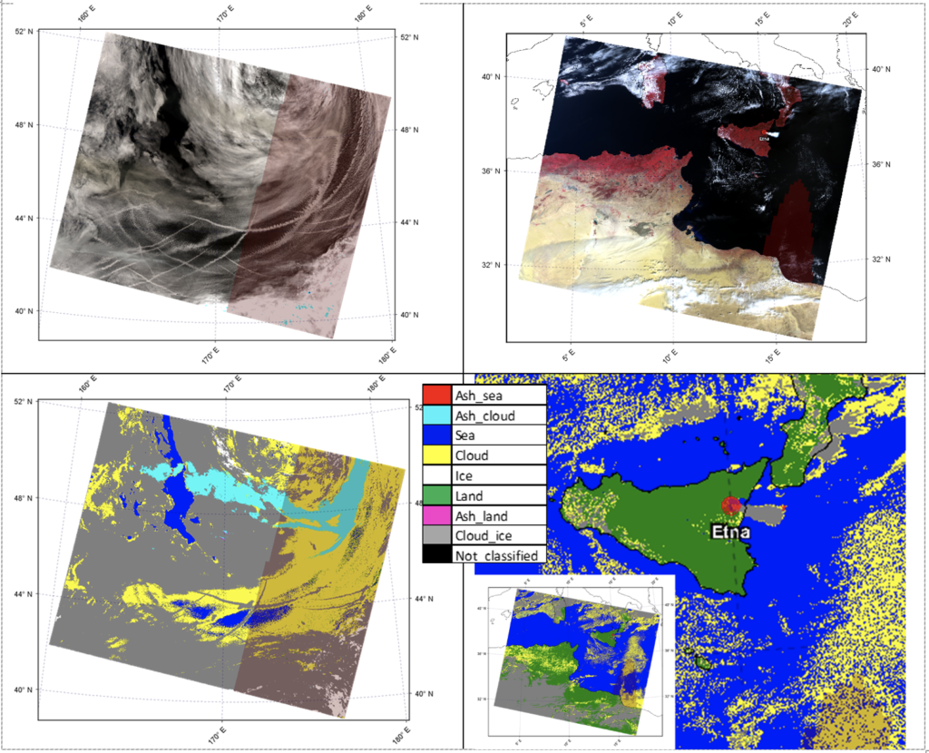
Lower Plates: NN image classification of the two SLSTR images.
The volcanic cloud particles retrievals were realized by considering three types of methodologies: Look Up Table (LUTp), Volcanic Plume Retrieval (VPR) and Neural Networks (NN). The LUTp and VPR methods were tuned and applied to Sentinel-3/SLSTR for the first time during the project, while the NN approach was specifically designed to use Sentinel-3/SLSTR as inputs. Radiative Transfer Model simulations (using MODTRAN v5.3) have been considered for producing synthetic training sets, which have been used in the training phase of the NN development and in the tuning of the LUTp and VPR to work with Sentinel-3/SLSTR. The quantitative products obtained are: effective radius (Re), Aerosol Optical Depth (AOD) and Mass (Ma) for volcanic particles such as ash, ice and water vapour.
Comparisons with Terra-MODIS, MSG-SEVIRI and Himawari-AHI were made to validate these parameters, showing good agreement. The figure below shows the three retrieval strategies applied to SLSTR image collected at 23:01 UTC on June 22, 2019 (Raikoke eruption). For validation the LUTp method was used to process the corresponding Terra MODIS image (22:55 UTC); the ash parameters maps show good agreement between all the SLSTR products obtained from the different retrieval procedures and with the results obtained with MODIS.
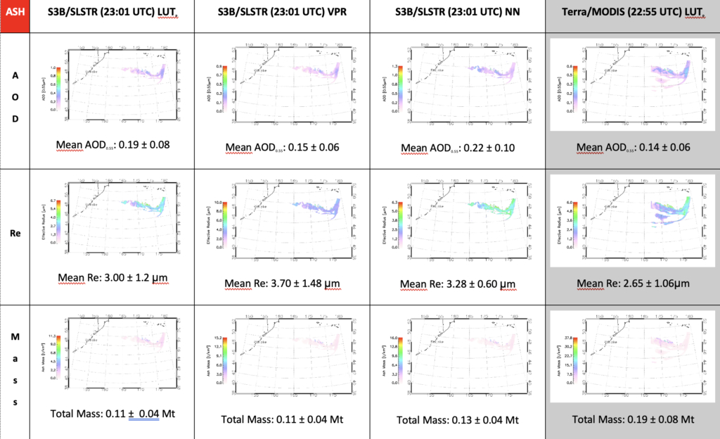
For each image the mean AOD, mean Re and Total ash Mass are also displayed.
Finally, the characteristic dual view of SLSTR has been exploited to retrieve the volcanic cloud height, one of the most important parameter to retrieve in particular for aircraft security. The method used is based on the spatial correlation between the sub-scenes of SLSTR stereo-pairs, which was derived by using the pattern matching principle to maximize some measure of the degree of agreement between the two images. Then a contour technique improves stereo matching confidence. This method has the advantage of being smoother than the pattern matching method (which is susceptible to heterogeneity in the thermal field). Validation of volcanic cloud height was performed using other techniques, such as the “dark pixel” (comparing the brightness temperature of the coolest volcanic cloud pixel with the atmospheric temperature profile in the same area) and the “shadow” technique (that uses the SLSTR visible channels to detect the length of volcanic cloud shadow caused by the sun).
Continue to the next article “VISTA innovative ground based monitoring systems“
*Matteo Picchiani, Engineer, Chief Technical Officer at GMATICS
Monitoraggio delle attività vulcaniche utilizzando Copernicus e dati a terra
a cura di Matteo Picchiani*
Parallelamente alle attività del progetto europeo DYDAS (cofinanziato dal programma CEF – Connecting Europe Facility), Matteo Picchiani (di GMATICS) ha guidato lo sviluppo del monitoraggio vulcanico dell’Agenzia spaziale europea utilizzando sensori SenTinel da un progetto fondato sull’approccio integrato (VISTA) (https://eo4society.esa.int/projects/vista/).
VISTA è stato realizzato da GEO-K, il primo spin-off dell’Università di Tor Vergata, in collaborazione con l’Istituto Nazionale di Geofisica e Vulcanologia e la società britannica AIRES TECH PLC.
Questo progetto mirava a sviluppare un nuovo insieme di algoritmi per caratterizzare gli effetti delle emissioni vulcaniche sulla terra e sull’atmosfera; tali informazioni sono fondamentali ai fini della sicurezza aerea e della protezione civile. In particolare, il focus principale del progetto è stato il recupero dei prodotti vulcanici mediante il radiometro Sentinels Sea and Land Surface Temperature Radiometer a bordo dei dati Copernicus Sentinel-3 (Sentinel-3/SLSTR), che non sono ancora applicati nel monitoraggio vulcanico operativo. Sono state sviluppate metodologie specifiche integrando tecniche di modellazione inversa (basate su modelli di trasferimento radiativo) con approcci di machine learning (ML) dedicati e producendo i seguenti risultati:
- Rilevamento di nubi vulcaniche di cenere, ghiaccio, particelle di vapore acqueo (wvp)
- Reperimento parametri cenere/ghiaccio/wvp (profondità ottica-AOD, raggio effettivo-Re, massa-Ma)
- Reperti della geometria delle nubi vulcaniche (altezza della sommità delle nubi vulcaniche-Hp ed estensione-Ep)
Inoltre, sono stati sviluppati due innovativi sistemi a terra, per il rilevamento delle nubi vulcaniche e il recupero dell’abbondanza e dell’altezza colonnare di SO2. Tali nuovi strumenti sono stati testati durante due principali campagne sul campo condotte sui vulcani Etna e Stromboli rispettivamente in marzo-aprile e luglio 2021.
Dopo la fase di sviluppo, tutte le procedure sono state testate e validate considerando diverse eruzioni recenti, come l’Anak Krakatau del 2018 (Indonesia), il Raikoke del 2019 (Russia) e l’Etna del 2021 (Italia).
Il rilevamento delle nuvole vulcaniche è stato realizzato con un approccio NN innovativo il cui addestramento è stato eseguito utilizzando i dati MODIS come informazioni proxy di SLSTR. L’algoritmo NN sviluppato si è dimostrato in grado di identificare non solo la nuvola vulcanica, ma anche di caratterizzare l’intera immagine satellitare. Sono state progettate le seguenti classi di output: cenere sul mare, cenere sulla terraferma, cenere sulle nuvole meteoriche, superficie terrestre, superficie del ghiaccio, superficie del mare, nubi meteorologiche dell’acqua e nubi meteorologiche del ghiaccio. Nella figura seguente sono mostrati due esempi di caratterizzazione SLSTR, ottenuti alle eruzioni del Raikoke e dell’Etna. Anche se gli scenari analizzati sono impegnativi per l’ampia distribuzione delle nuvole meteorologiche, l’algoritmo NN è in grado di caratterizzare l’intera immagine rilevando nuvole meteorologiche composte da goccioline d’acqua (gialle) e ghiaccio (grigio), mare (blu) e terra (verde ) superfici e nubi di cenere vulcanica. I pixel di quest’ultima classe per l’eruzione di Raikoke sono ciano, indicando che l’intera nuvola vulcanica è al di sopra della nuvola meteorologica. L’eruzione dell’Etna del 12 marzo 2021 è stata invece caratterizzata da un alto contenuto di ghiaccio. La classificazione NN è in grado di rilevare il ghiaccio presente nella nuvola vulcanica; il pennacchio è classificato, infatti, come classe di nuvola di ghiaccio (grigio).
Lower Plates: NN image classification of the two SLSTR images.
I recuperi di particelle di nubi vulcaniche sono stati realizzati considerando tre tipi di metodologie: Look Up Table (LUTp), Volcanic Plume Retrieval (VPR) e Neural Networks (NN). I metodi LUTp e VPR sono stati ottimizzati e applicati a Sentinel-3/SLSTR per la prima volta durante il progetto, mentre l’approccio NN è stato specificamente progettato per utilizzare Sentinel-3/SLSTR come input. Le simulazioni del modello di trasferimento radiativo (utilizzando MODTRAN v5.3) sono state prese in considerazione per la produzione di set di addestramento sintetici, che sono stati utilizzati nella fase di addestramento dello sviluppo NN e nella messa a punto di LUTp e VPR per funzionare con Sentinel-3/SLSTR. I prodotti quantitativi ottenuti sono: raggio effettivo (Re), Profondità Ottica Aerosol (AOD) e Massa (Ma) per particelle vulcaniche come ceneri, ghiaccio e vapore acqueo.
Sono stati effettuati confronti con Terra-MODIS, MSG-SEVIRI e Himawari-AHI per convalidare questi parametri, mostrando un buon accordo. La figura seguente mostra le tre strategie di recupero applicate all’immagine SLSTR raccolta alle 23:01 UTC del 22 giugno 2019 (eruzione Raikoke). Per la validazione è stato utilizzato il metodo LUTp per elaborare l’immagine Terra MODIS corrispondente (22:55 UTC); le mappe dei parametri delle ceneri mostrano un buon accordo tra tutti i prodotti SLSTR ottenuti dalle diverse procedure di prelievo e con i risultati ottenuti con MODIS.
For each image the mean AOD, mean Re and Total ash Mass are also displayed.
Infine, la caratteristica doppia visuale di SLSTR è stata sfruttata per recuperare l’altezza della nuvola vulcanica, uno dei parametri più importanti da recuperare in particolare per la sicurezza degli aeromobili. Il metodo utilizzato si basa sulla correlazione spaziale tra le sub-scene delle stereo-coppie SLSTR, che è stata derivata utilizzando il principio del pattern matching per massimizzare una certa misura del grado di accordo tra le due immagini. Quindi una tecnica di contorno migliora la sicurezza della corrispondenza stereo. Questo metodo ha il vantaggio di essere più fluido del metodo di pattern matching (che è suscettibile di eterogeneità nel campo termico). La convalida dell’altezza delle nubi vulcaniche è stata eseguita utilizzando altre tecniche, come il “dark pixel” (confrontando la temperatura di luminosità del pixel della nuvola vulcanica più fredda con il profilo della temperatura atmosferica nella stessa area) e la tecnica “shadow” (che utilizza la SLSTR canali visibili per rilevare la lunghezza dell’ombra della nuvola vulcanica causata dal sole).
Continua tramite l’articolo “VISTA innovativi sistemi di monitoraggio a terra“
*Matteo Picchiani, Engineer, Chief Technical Officer at GMATICS